About Me

My photo
Born in Edinburgh in 1951, my career took me to many parts of the world but finally left me in Spain where i've lived since 1981. I have business interests which leave me enough time to work the Salou-spotlight website. Our aim is to help people who are interested in this area of Spain for holidays or longer term.

Sunday, July 27, 2008

Walk: Vilella Baixa to Cabacés.

In summer, the humidity on the coast can reach 98%, so no matter how hot the air temperature is, it can feel seriously uncomfortable. My answer, once a week is to get inland and higher up. It can be a double edged sword as in the interior you can experience dry heat which is exhausting and so it proved today.


I decided to head for the small village of Vilella Baixa in the Priorat region. Driving up there from Salou, on the coast, is a treat as you bypass the city of Reus and start to head into pine forested country. As you reach the town of Falset the country is already wooded and clearly "farming" land. Gratallops is another centre of agriculture but even on Sunday there is a certain village atmosphere with terrace furniture on the pavement and a handful of locals enjoying a morning drink. The road, reconditioned recently, still needs concentration as it heads inland on a windey track though pine forests alive with cicadas sounding like an orchestra of demented babies with rattles.


Arriving at Vilella I soon found the start of the trail and headed down towards the 15th century bridge which crosses the Rio Montsant (We are now in the Montsant National Park). The trail is probably extremely ancient. Before Spain had roads, all commerce was by donkey and Ox Cart along narrow trails and this one shows signs of very old paving - slabs of the local red sandstone which were probably laid 2000 years ago are still in evidence though many have been quarried for walls except where the locals have recognised the need for a good sound road.


The 15th century bridge at Vilella Baixa.


The track follows a Westward path, paralleling the Rio Montsant and climbing slowly through productive Vineyards. This is Priorat, the country of strong, earthy, dark wines of enormous character. Priorat wines have gained a worthy recognition worldwide and the wealth they have brought to this region is reflected in the investment in land, and buildings throughout the area.


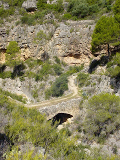
As you move West the trail firstly passes the verdant valley of the Rio Montsant, then climbs steeply and soon you come to the Gorge of Cuevaloca, literally the "Mad Cave" though I could see no cave, just a sharp drop to a beautiful bridge built in the 1st century A.D. which confirms the pedigree of this important road as a Roman trail. Crossing over the gorge, the trail rises steeply again and enters the forest where it strives to reach the Coll de Cabacés on a two mile steep rocky path. Beyond the coll is the town, but in the 32 degree heat, after two attempts to rest and start again I finally decided to turn back.


I've become lost on trails before, but never quit, however I was getting short of water and didn't know what lay beyond the ridge so this was a sensible decision. The walk back to Vilella was pleasant and the cool beer at the end a necessary treat, after a pint of iced water!


This image is of the Roman bridge over the CovaLoca Gorge.


Whatever, walking in this area of Catlunya can be demanding, but it is always rewarding. In winter the weather is mild, so you can attempt some of the more difficult areas or just look out for migratory birds in the valleys and streams where they pass the winter. In Spring you can walk or cycle the Via Verde railway trails which have been converted for recreation, and enjoy an orange picked freshly from a tree. In summer you can try to give yourself heart failure on some of the limitless trails, as I do!

Sunday, July 20, 2008

Spains "Vias Verdes" the Greenways.


In the 19th century, before motorways and even decent paved roads, there was a serious need for transport of merchandise and people, and in the industrial age the first solution was waterways, rapidly followed by the Railway. Railways were a "quick fix" you could make one as long or as short as you needed. They were perfect for mining regions where tons of ore had to be shifted, and as long as the tracks fitted (the gauge) you could join them up and share the resource between villages, provinces and eventually, nationally.


Spain built over 5000 kilometers of narrow gauge railways between the 1850's and 1960's. They carried farm produce to the coast and fertilisers and machinery back to the interior. The railways were mostly run by small, locally financed companies, and eventually in the 1970's they had become economically unviable so they closed. Happily, someone came up with the idea of recovering the rails and paving the tracks for cyclists and walkers. To date, some 1800 kilometers of these marvellous ways have been made available free to the public, and that's in Spain alone! Europe wide there are thousands of kilomters of "Greenways", perfect, safe, easy walkways, often in the most beautiful countryside imaginable.


The nearest Via Verde to Salou is that from "Roquetes", near Tortosa, to "Pinell de Brai" near Gandesa. It follows the Ebro river valley Northwest and passes through Orange groves before paralleling the river and reaching the town of Xerta. The first tunnels then appear, you'll need a torch! As you go noth past Benifallet the country becomes more rugged and beautiful. There are lots of tunnels here, some just a hundred metres long but some three hundred and very dark. When you emerge into the sunlight you might find a plain covered in almond trees, then the next one a deep ravine with falling water and kingfishers flashing over the crystal pools.


Spring Flowers decorate the Via Verde de Baix Ebre near Roquetes. March 2007


The old stations are still there, though they're mostly ruined now. I did find one down on the stretch into Valencia province which had been converted into a not bad 3 star Hotel.


Once you've done the "Baix Ebre" (Low Ebro - 25 kilometer) stretch you're a convert and start on the stage which goes from Pinell de Brai to Arnés (30 kilometers). I do the Vias in stages. I search Google Earth for the stations then drive thre and do a "stage walk" of about 20 kilometers out and back, usually taking in a station or two. By doing it this way I completed this section, known as the Via verde de Terra Alta (the High Country) in three stages.

Mrs Max looks out over the Ebro Valley near Benifallet.
The Via goes on from Arnés towards Alcañiz in the province of Teruel, and i've done all of the paved stretches, and look forward to doing more when they're completed.
Meanwhile we've also been in winter to the Vias in Girona province and have investigated many of the other Vias all over Spain.
CONTACT INFORMATION: The Via Verde de Baix Ebre lies mainly in the "Parc Nacional de Les Ports". The entrance to the South end of the Via is at Roquetes (Tortosa). Drive down the AP7 taking the Tortosa/Aldea exit and follow the dual carriageway to Tortosa. When you get to a roundabout with a "Star" motif turn left over the river for "Roquetes/Gandesa". Follow through Roquetes finding signs to "Informacio PN Les Ports" these bring you to the edge of town, and on the left the information office. You can park by the offices and the entrance to the Via verde is across the road. Office opening hours 10 - 13 and 17 - 20 Mon-Sat. 10 - 13 Sundays.

Walk: Sant Joan to Albarca, Montsant Mountains.


This is a fairly easy walk for the moderately fit. 7.2 kms. 190metres max. displacement. It is mostly level, but you'll want to wear good trainers with some grip, take 1 litre of water and maybe a sandwich or a couple of biscuits in a small rucksack. Mobile phone, switched off just in case of problems, and a pair of Binoculars.


How to get there: From Reus or Salou: Take the Westbound T-11 Reus bypass towards Falset. This ends just past Reus and becomes the N-420, shortly after there's a right turn to Borges del Camp and Alforja (C-242) Follow this to Cornudella de Montsant, passing through there until just as you leave town there's a tarmac track on the left (opposite a sign for Panta de Siurana) which takes you up (3 kms) to the Chapel of Sant Joan de Codolar. It's a narrow track, steep and winding but paved all the way so an ordinary car driven carefully can make it. Park outside the chapel and walk into the yard. Keeping right, you pass between the chapel building and the steep rocks and arrive at a signpost to "Albarca" which you follow. You are now on the GR174 which is signalled periodically with White over red blaze marks. Note that parallel blaze marks mean "correct route" crossed marks mean "wrong route". There's only one point where you can go wrong so watch for it. You continue along the lamost level route 'til you get to the Refuge of Albarca.


The views over the valley are fine, and if there's a breeze it's a special treat. Watch out for local fauna. In Winter and spring you might see wild goats and lots of flowers after rains. In high summer, lizards and the occasional snake.


The return path is the same. When you get back to the Chapel, after a rest go into Cornudella for something to eat or go down to the Siurana reservoir for a swim in summer. You can also rent canoes there in season.

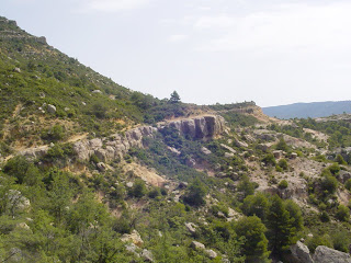
This shows the rock ledge that the trail follows.