About Me

My photo
Born in Edinburgh in 1951, my career took me to many parts of the world but finally left me in Spain where i've lived since 1981. I have business interests which leave me enough time to work the Salou-spotlight website. Our aim is to help people who are interested in this area of Spain for holidays or longer term.

Sunday, August 10, 2008

The Monastery of Santes Creus.


I've lived in this area for 25+ years and heard about the monasteries and churches, however i've only seen a tiny fraction of what they have to offer. As it's a bit hot for sustained effort in August, I decided to take a stroll around the Monastery of Santes Creus, just a half hour drive from Salou. It's one of the Cistercian monasteries and the building has been messed about in so many ways, but it's set in some very pretty country with lots of broad leaved trees which cool the atmosphere.

The main square at Santes Creus.


There are lots of nooks and crannies to poke around in, and one of the best finds is a tiny cloister round an old well of the main square. This uses the old Roman principle of a shady area with a draught passing through and damp air as natural air conditioning.


Surprisingly, this well known site was not massively busy on the Sunday when I visited, however my timing was not too good as they close at 1.30 pm. By way of compensation there are many small bars and restaurants around the charming narrow village steet which leads up to the site, and the smell of woodsmoke gives way to the aroma of roasting sausages, and grilling lamb chops, reminding one that there are some excellent red wines available around here. If only I didn't have to drive back...sigh..never mind, one decent beer is acceptable with a nice piece of rare steak, some flame roasted green peppers and sauteed potatoes and a green salad on the side.

The Cloister and well of Santes Creus.

The buildings are a nice study for anyone keen on mediaeval architecture with lots of nice detail in the masonic style - strange creatures chewing their own tails and so forth.


Pseudo Celtic creatures in the 13th century (earlier?) style.


There seem to be many inhabited houses around the square and I need a second visit, better timed, to learn more about this fascinating place. The last picture is of the 18th century building and archway which leads to the main gate. One of those nice restaurants I mentioned is right there.
Update: True to my word, I returned to Santes Creus with my Wife and Nephews towards the end of August, and in plenty of time to see inside the restored monastery. It is magnificent! The cloisters hold the most astonishing collection of carving i've seen since Roslin Abbey near Edinburgh. There are so many ages represented here from the 12th to the 19th century. There's a visitor centre which shows a film about the Monasteries of the area - the Englsih version screens at 12:30 but be in plenty of time.
We actually didn't get into the church itself as a Mass was being held, but if you get there before 11 you can either join the Mass or see the church before it begins. I'm going again when I get a better camera - those carvings merit a collection of pictures.
How to get there: From Tarragona take the main road to Valls, on the Valls bypass take the C51 towards El Vendrell. Santes Creus is well signposted from there. On the return trip, try going via Aiguamurcia, it's a pleasant treed valley and brings you back by another route to Tarragona.





Sunday, July 27, 2008

Walk: Vilella Baixa to Cabacés.

In summer, the humidity on the coast can reach 98%, so no matter how hot the air temperature is, it can feel seriously uncomfortable. My answer, once a week is to get inland and higher up. It can be a double edged sword as in the interior you can experience dry heat which is exhausting and so it proved today.


I decided to head for the small village of Vilella Baixa in the Priorat region. Driving up there from Salou, on the coast, is a treat as you bypass the city of Reus and start to head into pine forested country. As you reach the town of Falset the country is already wooded and clearly "farming" land. Gratallops is another centre of agriculture but even on Sunday there is a certain village atmosphere with terrace furniture on the pavement and a handful of locals enjoying a morning drink. The road, reconditioned recently, still needs concentration as it heads inland on a windey track though pine forests alive with cicadas sounding like an orchestra of demented babies with rattles.


Arriving at Vilella I soon found the start of the trail and headed down towards the 15th century bridge which crosses the Rio Montsant (We are now in the Montsant National Park). The trail is probably extremely ancient. Before Spain had roads, all commerce was by donkey and Ox Cart along narrow trails and this one shows signs of very old paving - slabs of the local red sandstone which were probably laid 2000 years ago are still in evidence though many have been quarried for walls except where the locals have recognised the need for a good sound road.


The 15th century bridge at Vilella Baixa.


The track follows a Westward path, paralleling the Rio Montsant and climbing slowly through productive Vineyards. This is Priorat, the country of strong, earthy, dark wines of enormous character. Priorat wines have gained a worthy recognition worldwide and the wealth they have brought to this region is reflected in the investment in land, and buildings throughout the area.


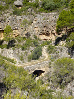
As you move West the trail firstly passes the verdant valley of the Rio Montsant, then climbs steeply and soon you come to the Gorge of Cuevaloca, literally the "Mad Cave" though I could see no cave, just a sharp drop to a beautiful bridge built in the 1st century A.D. which confirms the pedigree of this important road as a Roman trail. Crossing over the gorge, the trail rises steeply again and enters the forest where it strives to reach the Coll de Cabacés on a two mile steep rocky path. Beyond the coll is the town, but in the 32 degree heat, after two attempts to rest and start again I finally decided to turn back.


I've become lost on trails before, but never quit, however I was getting short of water and didn't know what lay beyond the ridge so this was a sensible decision. The walk back to Vilella was pleasant and the cool beer at the end a necessary treat, after a pint of iced water!


This image is of the Roman bridge over the CovaLoca Gorge.


Whatever, walking in this area of Catlunya can be demanding, but it is always rewarding. In winter the weather is mild, so you can attempt some of the more difficult areas or just look out for migratory birds in the valleys and streams where they pass the winter. In Spring you can walk or cycle the Via Verde railway trails which have been converted for recreation, and enjoy an orange picked freshly from a tree. In summer you can try to give yourself heart failure on some of the limitless trails, as I do!

Sunday, July 20, 2008

Spains "Vias Verdes" the Greenways.


In the 19th century, before motorways and even decent paved roads, there was a serious need for transport of merchandise and people, and in the industrial age the first solution was waterways, rapidly followed by the Railway. Railways were a "quick fix" you could make one as long or as short as you needed. They were perfect for mining regions where tons of ore had to be shifted, and as long as the tracks fitted (the gauge) you could join them up and share the resource between villages, provinces and eventually, nationally.


Spain built over 5000 kilometers of narrow gauge railways between the 1850's and 1960's. They carried farm produce to the coast and fertilisers and machinery back to the interior. The railways were mostly run by small, locally financed companies, and eventually in the 1970's they had become economically unviable so they closed. Happily, someone came up with the idea of recovering the rails and paving the tracks for cyclists and walkers. To date, some 1800 kilometers of these marvellous ways have been made available free to the public, and that's in Spain alone! Europe wide there are thousands of kilomters of "Greenways", perfect, safe, easy walkways, often in the most beautiful countryside imaginable.


The nearest Via Verde to Salou is that from "Roquetes", near Tortosa, to "Pinell de Brai" near Gandesa. It follows the Ebro river valley Northwest and passes through Orange groves before paralleling the river and reaching the town of Xerta. The first tunnels then appear, you'll need a torch! As you go noth past Benifallet the country becomes more rugged and beautiful. There are lots of tunnels here, some just a hundred metres long but some three hundred and very dark. When you emerge into the sunlight you might find a plain covered in almond trees, then the next one a deep ravine with falling water and kingfishers flashing over the crystal pools.


Spring Flowers decorate the Via Verde de Baix Ebre near Roquetes. March 2007


The old stations are still there, though they're mostly ruined now. I did find one down on the stretch into Valencia province which had been converted into a not bad 3 star Hotel.


Once you've done the "Baix Ebre" (Low Ebro - 25 kilometer) stretch you're a convert and start on the stage which goes from Pinell de Brai to Arnés (30 kilometers). I do the Vias in stages. I search Google Earth for the stations then drive thre and do a "stage walk" of about 20 kilometers out and back, usually taking in a station or two. By doing it this way I completed this section, known as the Via verde de Terra Alta (the High Country) in three stages.

Mrs Max looks out over the Ebro Valley near Benifallet.
The Via goes on from Arnés towards Alcañiz in the province of Teruel, and i've done all of the paved stretches, and look forward to doing more when they're completed.
Meanwhile we've also been in winter to the Vias in Girona province and have investigated many of the other Vias all over Spain.
CONTACT INFORMATION: The Via Verde de Baix Ebre lies mainly in the "Parc Nacional de Les Ports". The entrance to the South end of the Via is at Roquetes (Tortosa). Drive down the AP7 taking the Tortosa/Aldea exit and follow the dual carriageway to Tortosa. When you get to a roundabout with a "Star" motif turn left over the river for "Roquetes/Gandesa". Follow through Roquetes finding signs to "Informacio PN Les Ports" these bring you to the edge of town, and on the left the information office. You can park by the offices and the entrance to the Via verde is across the road. Office opening hours 10 - 13 and 17 - 20 Mon-Sat. 10 - 13 Sundays.

Walk: Sant Joan to Albarca, Montsant Mountains.


This is a fairly easy walk for the moderately fit. 7.2 kms. 190metres max. displacement. It is mostly level, but you'll want to wear good trainers with some grip, take 1 litre of water and maybe a sandwich or a couple of biscuits in a small rucksack. Mobile phone, switched off just in case of problems, and a pair of Binoculars.


How to get there: From Reus or Salou: Take the Westbound T-11 Reus bypass towards Falset. This ends just past Reus and becomes the N-420, shortly after there's a right turn to Borges del Camp and Alforja (C-242) Follow this to Cornudella de Montsant, passing through there until just as you leave town there's a tarmac track on the left (opposite a sign for Panta de Siurana) which takes you up (3 kms) to the Chapel of Sant Joan de Codolar. It's a narrow track, steep and winding but paved all the way so an ordinary car driven carefully can make it. Park outside the chapel and walk into the yard. Keeping right, you pass between the chapel building and the steep rocks and arrive at a signpost to "Albarca" which you follow. You are now on the GR174 which is signalled periodically with White over red blaze marks. Note that parallel blaze marks mean "correct route" crossed marks mean "wrong route". There's only one point where you can go wrong so watch for it. You continue along the lamost level route 'til you get to the Refuge of Albarca.


The views over the valley are fine, and if there's a breeze it's a special treat. Watch out for local fauna. In Winter and spring you might see wild goats and lots of flowers after rains. In high summer, lizards and the occasional snake.


The return path is the same. When you get back to the Chapel, after a rest go into Cornudella for something to eat or go down to the Siurana reservoir for a swim in summer. You can also rent canoes there in season.

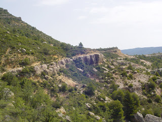
This shows the rock ledge that the trail follows.


Tuesday, June 24, 2008

Put it there - positioning engineering structures.

For twenty years from 1975 to 1995 my job was to place large engineering structures, such as oil platforms, at sea.


I became involved with this as a consequence of my training as a Radio Officer in the U.K. Merchant Navy. In the mid 1970's the Merchant fleet was reducing fast due to the Oil crises and the growth of low cost Greek and Liberian fleets, so I was fortunate to be invited to join a specialist group using innovative acoustic techniques - similar to echosounders - to position the research vessels then working to explore the North Sea Oil Fields.

In those pioneer days, GPS had never been thought of so we used land based Radio wave systems which had been adapted from WWII bombing aids, accurate to only about 200 metres, at best. However in the early 70's a very clever man called John Partridge designed a way of using echo sounders to locate "beacons" on the seabed with an accuracy of about one metre. We used the radio systems to lay networks of these seabed beacons and these were then adjusted to give very accurate results for oil drilling platforms. It was exciting "leading edge" stuff, and made us feel pretty cocky.

Most of the early North Sea work was geological sampling using core samplers and sediment grabs. The geologists used sensors to sniff for oily gas in the mud. We young blades learned a lot of this tehnology which stood us in good stead as the UK oil industry grew and carried us with it on a wave of investment capital. After the testing came the drilling, and we steered the "Rigs" onto location with our magical techniques. Good money, great food and very little time off!

Once the oil was discovered we learned about the construction of, and positioning of the huge production platforms which sit on the seabed rather than floating - more new ideas, invention and excitement. My contributions (and I will defend this) were the Underwater Gyrocompass and the electronic azimuth sensor, both devices which helped steer vessels and connect pipelines. My landmark moment was being on the team which positioned the 200.000 ton Ninian Central platform. This concrete monster was floated out from Loch Kishorn in Scotland to a site between Scotland and Norway. The circular base had a diameter equivalent to Trafalgar Square, and we placed it within three metres, and orientated less than 1.5 degrees from the design specs. A proud, but sweaty moment.

Over the next few years as these solid objects such as oil platforms created new "landmarks" we established radio beacons on them and soon the satellite age arrived and suddenly we had another tool. Satellites helped us confirm the thousands of points we had established out in the North Sea on platforms, however this brought it's own problems. The "Median Line between countries states who owns the oil below, and one of our tasks was to inform the Oil comapnies that we'd found a 200 metre error in the line. Long Story Short - it cost an American Oil Company about 200 million dollars in potential revenue when we moved the line!

In 1981 I moved to Spain where some oil work was taking place off Tarragona. Although I was then considered "old" by industry standards (I was 30) I soon managed to wangle my way back to operational status, out of the office and back onto "the Rigs". The routine was to set up a network of radio beacons on shore and fly a team, by helicopter, to the rig which would be under tow to the site, usually with three tugs. The equipment on board would compute the position, then the "towmaster" could use that information to bring the rig to the desired point where previously, seismic vessels (using the same positioning network) had detected a subsea structure which might contain oil.

By 1985 Oil prices had fallen to about $12 barrel so the industry was looking weak. I bought out the Spanish company along with a partner and good Friend, Victor Valck and kept it running while looking for new markets. We soon discovered the Telephone Cable business. British Telecom was in contact with the Spanish "Telefonica" company who planned to lay a network of the new fibre optic cables between the U.K. , U.S.A. , Africa and the Canary and Balearic Isles. This was perfect as we had both the positioning technology, and the local knowledge to provide diving and support services to the "beachmasters" who arrange the jointing of the cables at the landing points. there followed a series of dream jobs in Asturias (North Spain) the Canaries, Morocco, France, Majorca, Menorca, Lisbon and Madeira, then one day someone in STC laboratories in England discovered a way to multiply the number of phone calls through a hair thick fibre optic cable (the technology is staggering!) from 100,000 to 10 million! End of cable laying, end of market.

Onwards and Upwards. At this point Victor decided to quit so we parted on good terms and he went on to live with his wife in Tenerife while I chased new horizons. Those included the gas pipeline over the strait of Gibraltar to Morocco, and the Electrical cable in the same area and eventually a series of dredging surveys for ports and beaches all around the coast of Spain, however in 2005 even these markets had dried up. There are now no private Oceanographic survey companies in Spain. Consultants from Holland do most of the work so I finally decided to quit and concentrate on my other businesses. It was sad parting company with my small boat, and selling off equipment which had cost, in its day, as much as five large Mercedes cars but now was worth nothing - such is progress in technology.

Whatever, I still have the memories of these marvellous pioneer days, those wonderful beaches, Rigs, Cable ships, long stormy nights in the North Sea on pipelaying barges, great food, good comrades and being immersed in non-stop technology growth and opportunity. Now I have new opportunities in other directions and I still have my zest for discovery!

Onward and Upward, or sideways.

Since I had a BUPA medical two years ago, and the medic told me to get out and walk a bit, i've taken him seriously and got into bipedal perambulation in a biggish way.

It's not that I had a serious problem. I'd just let middle age overtake me, enjoyed the beer and crisps too much and built myself a spare tyre, along with a "marginal high blood pressure and cholesterol level" to use the medical terms...In other words I was becoming a fat lazy bastard.

I've always enjoyed my own company (how vain is that?) and of recent years i've had some interesting work (see attached blog item entitled "put it there") which allowed me to travel and keep myself fit and solvent, but this has sadly gone and been replaced with a more sedentary lifestyle which led me to the standard family shape of - a bit pudgy round the middle.

After a slow start, I got into the old phrase "early to bed early to rise, makes a man tired, cranky but slightly thinner"....and went out to walk our local beach each day at sunrise. It's a three kilometer march and was a dawdle as I wasn't THAT unfit. I started to like it, and one day broke into a trot, then after 100 metres found I was totally out of puff, so decided I needed to do this a stage at a time. I kept setting targets - end of the beach and back as far as the tree with the scabby warts - for a week, then if I felt like it, as far as the portaloo they've built for the workers on the new pavement project..etc, until after a year I was running the whole beach.

When the first winter came round I saw a programme on Spanish TV about something called the "Vias Verdes". This showed happy, mostly elderly or severely enthsiastic sport nuts on bikes, travelling on flat, paved converted railways. It looked great, so I investigated and found that Spain has 1600 kilometers of rural railways which have been converted to walking and cycling tracks. This was just what i'd been after...great scenery, flat paved routes and above all well away from Salou so I could get a bit of a change of scene. The neares Via Verede to us is the "Baix Ebre" or Low Ebro River Valley which measures 26 kilometers. It's a bit of a drive to the start point but I went there and did a notable 22 kilometers from Tortosa to Xerta and back on the first day. That was a bit of a fast learning curve as I found that my trainers, from Decathlon, were actually a tiny bit too small and i'd bruised my toes, however I learned fast, got myself some nice soft impact trainers plus a pair of fell boots, some shorts and socks.

Within three months i'd not only done the "Baix Ebre" out and back in stages, but found the extension of that trail which ges west. called the "Terra Alta", another 30 kilometers and done that too.

Since then i've discovered a marvellous site operated by the regional government the "Generalitat de Catalunya" www.gencat.cat/palaurobert which gives routes for walking, cycling and driving...on a well organised and easy to use site. Ive taken myself off most Sundays to a valley, mountain or forest and trekked around getting wet, sweaty, scratched, stung and completely exhausted and VERY happy. Een the wife and several friends have become enthused, so ive started to store some of the less strenuous and more interesting routes so I can take them along.

So my exercise routine now consists of weekday morning walk/run events lasting 30 minutes. Sunday specials - either one of the local Fun Run routes - 10 kilometer power walk, or a hill somewhere , usually half an hours drive away. End result I am now far more motivated, a good deal slimmer and much fitter than I was, plus it's keeping my eyes open to what's around in Catalunya.

Who Knows where the time goes?

When I was young, i.e from seventeen to about 25 years old, I was very fond of Folk music. At that time, in the late 1960's and early 1970's there was a revival of English Folk music, embodied for me in the recordings of Fairport Convention. There was a nice anarchic situation around "Fairport" with musicians coming and going, and many great names such as Dave Swarbrick and Sandy Denny were regulars, however the group as an entity survived many years and produced some magical albums before the "Folk Rock" movement - perhaps best represented by Tim Hart and Maddy Prior made the Genre more commercial with their band "Steeleye Span". I shared a flat in Edinburgh with a guy called Dave Tulloch who played with "5 Hand Reel" an Irish - Scottish Folk Rock band, popular in Germany, Holland and Belgium. Their music was both original - good remakes of traditional sad songs, and exciting - riotous jigs and reels for cheering yourself up.

My hobby while at School and College was Theatre Lighting and effects, and living in Edinburgh I had the pleasure and opportuity, during the Edinburgh Festivals to work with what were then, Big Names. I have lit concerts by Barbara Dickson, Billy Connoly, Planxty, JSD Band, Hawkwind, I can hear you say WHO??? Great days! Lots of beer and nookie.